Your backyard isn’t just a garden; it’s a potential scientific research station that can provide crucial data for species conservation.
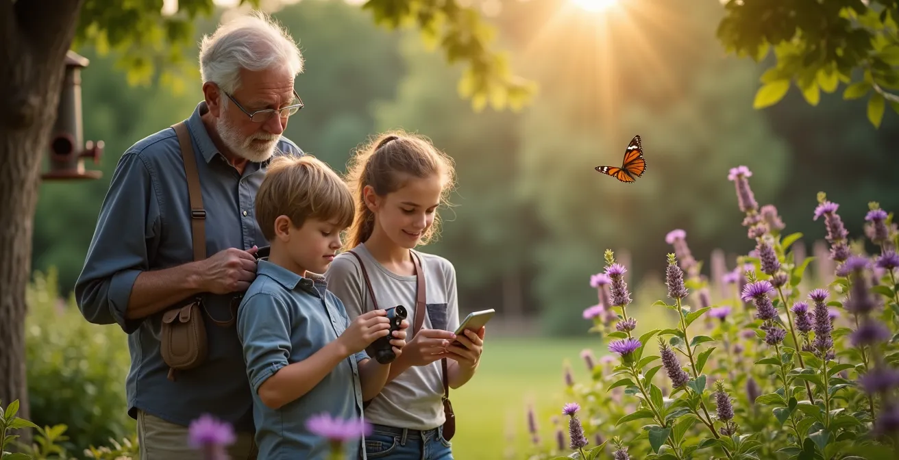
- Using apps like iNaturalist transforms simple photos into verifiable scientific records that researchers use.
- Strategic planting of native species and mindful yard care create essential habitats and data points for at-risk wildlife.
Recommendation: Start by documenting one native plant or insect in your area and uploading it—your first step into becoming a citizen scientist.
Watching news about dwindling wildlife populations can leave you feeling powerless, wondering what one person can possibly do. Many of us who love nature want to contribute, but the advice often feels small or disconnected from the larger scientific effort. We’re told to build a birdhouse or plant some flowers, actions that are well-intentioned but can feel like a drop in the ocean. The crucial link between our backyards and the researchers on the front lines of conservation seems missing.
But what if the most powerful tool for conservation was already in your pocket? What if your garden, your city balcony, or even the weeds in a local park could become critical data-collection outposts? The key isn’t just to passively attract wildlife, but to actively and intelligently document it. The shift is from simple gardening to data-driven gardening, where every observation can become a valid, useful piece of the puzzle for scientists tracking endangered species.
This guide will transform your perspective. It’s not just about “helping” wildlife in a generic sense; it’s about generating scientifically valuable information. We will show you how to turn your small patch of the world—from a single container plant to a community green space—into a hub of activity that directly informs conservation strategy. You don’t need a biology degree, just a curious mind and a smartphone.
This article explores the concrete actions you can take, moving from the personal to the community level. You will learn how to create vital habitats, use powerful mobile apps to log your findings, make informed choices about your plants, and even help your community prepare for the return of larger native species. Let’s begin your journey as a citizen scientist.
Summary: How Your Backyard Can Become a Vital Outpost for Tracking Endangered Species
- Why Do Monarch Butterflies Need Your City Balcony?
- How to Use iNaturalist to Generate Valid Scientific Data?
- Native Wildflowers or Exotic Blooms: Which Feeds More Bees?
- The Fall Cleanup Mistake That Destroys Hibernating Insects
- When to Stop Pruning Hedges to Protect Nesting Birds?
- How to Prepare a Community for the Return of Wolves or Lynx?
- How to Share Photos Without Exposing Fragile Spots to Crowds?
- How Can Rewilding Create More Jobs Than Traditional Farming in Marginal Areas?
Why Do Monarch Butterflies Need Your City Balcony?
The epic migration of the monarch butterfly is one of nature’s great spectacles, but it’s a journey fraught with peril. These iconic insects face a severe lack of habitat along their migratory routes, especially in urban areas. Cities can become “nectar deserts,” leaving monarchs without the fuel they need to survive. This is where your balcony or small patio becomes a surprisingly crucial piece of the conservation puzzle. By creating a monarch waystation, you are essentially building a vital refueling stop in an urban landscape.
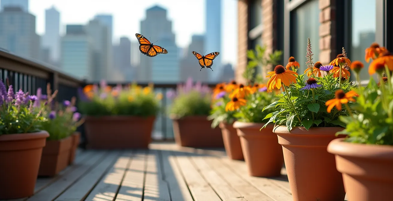
Transforming a small urban space doesn’t require a massive yard. It’s about providing two key resources: milkweed for caterpillars and nectar-rich flowers for adults. The success of this approach is not just theoretical. Consider the Toronto shoreline residential development project, which successfully integrated monarch habitat into its design. By using vegetative matting techniques, the project created an immediate nectaring habitat, resulting in an “orange-filled spectacle” for residents and a lifeline for migrating monarchs. Your balcony can be a miniature version of this success, a vibrant micro-habitat contributing to a larger ecological corridor.
Case Study: Toronto Urban Monarch Habitat Initiative Success Story
A Toronto shoreline residential development project successfully integrated monarch butterfly habitat within migratory corridors. The developer obtained construction approvals after demonstrating that monarch habitats could be maintained on-site. Using vegetative matting techniques, the project provides rapid soil stabilization with immediate nectaring habitat for monarchs, creating an ‘orange-filled spectacle’ for GTA residents annually.
The key is selecting the right plants. You’ll need regional native milkweed species, which are the only plants monarch caterpillars eat. It’s critical to avoid tropical milkweed, as it can disrupt migration patterns. Pair this with a succession of native nectar plants that bloom from spring to fall, ensuring a consistent food source. Using containers with good drainage and a depth of at least 12 inches for milkweed roots will set you up for success. By adding a shallow water source with pebbles for landing, you’ve created a complete, life-sustaining oasis.
How to Use iNaturalist to Generate Valid Scientific Data?
You’ve spotted a strange beetle on your milkweed plant. You snap a photo. What happens next is what separates a casual observation from a valuable piece of scientific data. This is where platforms like iNaturalist come in, acting as a bridge between your curiosity and global biodiversity databases. The app isn’t just a social network for nature lovers; it’s a powerful engine for generating verifiable information that scientists actively use to track population trends, species distribution, and the effects of climate change.
The genius of iNaturalist lies in its community-driven data validation system. Not every photo becomes a scientific record immediately. Your observation must achieve “Research Grade” status. This requires a clear photo or audio recording, an accurate date and location, and, most importantly, a community consensus on the species identification. When at least two-thirds of the identifiers agree on your organism, your observation is elevated. This rigorous process is incredibly effective; an internal experiment by iNaturalist confirmed an estimated 95% accuracy rate for Research Grade observations. This level of reliability is why your data can be trusted and integrated into major scientific initiatives.
Understanding the different quality levels is key to becoming an effective contributor. The table below breaks down the journey of an observation from a casual sighting to a research-ready data point.
| Quality Level | Requirements | Scientific Use |
|---|---|---|
| Casual | Missing date, location, or evidence; captive/cultivated organisms | Not shared with research databases |
| Needs ID | Has photo/audio, date, location, wild organism; awaiting species confirmation | Some databases accept with caveats |
| Research Grade | 2/3+ community agreement on species-level ID, meets all verifiable criteria | Shared with GBIF, used in peer-reviewed research |
By aiming for Research Grade, you ensure your efforts are not in vain. Focus on taking clear, identifiable photos, providing precise location data (unless it’s a threatened species), and engaging with the community to help identify others’ sightings. This is how you transform a simple photo into a permanent, valuable contribution to our collective ecological literacy.
Native Wildflowers or Exotic Blooms: Which Feeds More Bees?
Walk into any garden center, and you’re faced with a dazzling array of flowers from around the world. It’s tempting to choose the biggest, brightest blooms. But when your goal is to support local wildlife, the origin of your plants matters profoundly. The debate between native and non-native (exotic) plants isn’t just about aesthetics; it’s about evolutionary biology. Native bees, butterflies, and other pollinators have co-evolved over millennia with native plants, creating a deeply specialized relationship that exotic species simply cannot replicate.
Many pollinators are specialists. They rely on specific plants for food or nesting materials. For example, pollinator research reveals that there are over 90 specialist bee species in New York state alone, each adapted to a particular group of native plants. An exotic butterfly bush might attract generalist species like honeybees, but it offers nothing to the specialist bees that are often most at risk. Choosing native wildflowers is an act of data-driven gardening; you are consciously providing resources for the specific, vulnerable wildlife of your region.
The superiority of native plants isn’t just theory. It’s backed by scientific evidence. A recent study powerfully illustrates this point, providing a clear verdict for conservation-minded gardeners.
Case Study: University of Florida Native Plants Study
University of Florida research demonstrates that native plants produce more flowers for pollinators under both full and partial irrigation, attracting more bees. Native plant species can support pollinator populations through dense floral displays, making them a key strategy for addressing global pollinator decline.
The takeaway is clear: if you want to feed more bees and support a wider diversity of pollinators, native plants are unequivocally the better choice. They are adapted to your local climate, require less water and maintenance, and, most importantly, provide the precise nutrition local wildlife needs to thrive. By prioritizing native species in your yard or on your balcony, you are creating a high-impact, low-effort conservation habitat that genuinely supports the entire food web.
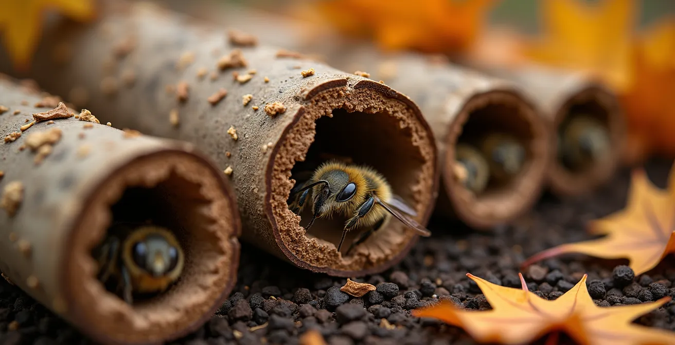
The Fall Cleanup Mistake That Destroys Hibernating Insects
As autumn leaves fall, there’s a deeply ingrained impulse to tidy up the garden. We rake every last leaf, cut back all the perennial stems, and strive for a neat, clean slate for winter. While this may satisfy our sense of order, it is an ecological disaster. This “scorched earth” approach to fall cleanup destroys the very micro-habitats that countless insects—including essential pollinators and beneficial predators—need to survive the winter. Queen bees, butterfly chrysalises, and the larvae of ladybugs and lacewings all overwinter in leaf litter and hollow stems.
Your “messy” garden is, in fact, a bustling winter nursery. The hollow stalks of perennials like coneflowers and bee balm provide perfect nesting chambers for solitary bees. Piles of fallen leaves offer insulation and protection for queen bumblebees and caterpillars that will become next year’s moths. By clearing everything away, we are inadvertently throwing away the next generation of life in our gardens. This is perhaps the most common and damaging mistake a well-meaning gardener can make.
The solution is to embrace a new, more patient approach to gardening. Leave the leaves where they fall, at least in your garden beds. They form a natural mulch that enriches the soil and protects overwintering life. Let your perennial stems stand through the winter. They provide both shelter and a food source for birds who will pick at the seed heads. The key is to wait until spring, and even then, to act with care. A good rule of thumb is to wait for at least one week of consistent 50°F (10°C) temperatures before you even think about cleaning up. This ensures that most hibernating insects have had a chance to emerge.
Checklist for Auditing Your Yard’s Hibernation Habitats
- Points of Contact: Identify all potential overwintering zones in your yard: leaf piles under trees, perennial flower beds, brush piles, and patches of bare soil.
- Inventory: List the specific perennial stems (e.g., coneflowers, black-eyed susans) and leaf types (e.g., oak, maple) that you are leaving in place for winter.
- Coherence: Confront your planned spring cleanup date with the “50°F/10°C for one week” rule. Are you being patient enough to let insects emerge?
- Habitat Quality: Assess your stem and brush piles. Are they just a random mess, or are they structured to provide hollow cavities and protection from wind and predators?
- Integration Plan: Create a three-step priority list for spring cleanup: 1) Leave the decomposed bottom layer of leaves, 2) Cut old stems to a height of 15-18 inches, and 3) Bundle these cut stems to create new bee hotels for the next season.
Adopting this wildlife-safe yard management strategy is a powerful act of conservation. It costs nothing, saves you labor, and has a direct, positive impact on the biodiversity of your local ecosystem.
When to Stop Pruning Hedges to Protect Nesting Birds?
Hedges are more than just green fences; they are vibrant, three-dimensional habitats. For many bird species, they are the equivalent of a fully-equipped housing development, offering safe nesting sites, a reliable food source of insects and berries, and cover from predators. However, a poorly timed trim can instantly destroy this delicate nursery. The most critical rule for wildlife-friendly hedge management is knowing when to put the shears away. The main bird nesting season is a protected period, and disturbing a nest during this time is not just harmful, but in many places, illegal.
Generally, you should avoid any pruning or major work on hedges from March through August. This window covers the nesting periods of most common garden birds, from early nesters like robins to later nesters like goldfinches. A single pass with a hedge trimmer can wipe out an entire clutch of eggs or fledglings in seconds. Before undertaking any work, even outside this core period, it’s essential to check carefully for any signs of active nesting. Look for birds repeatedly flying to the same spot with food or nesting material in their beaks, or listen for the faint cheeping of young birds.
Citizen science programs have been instrumental in highlighting the immense value of unpruned hedges. Volunteers are on the front lines, documenting how these linear parks function as complete ecosystems.
Case Study: Community Wildlife Monitoring in Urban Hedgerows
The British Bat Survey and Living with Mammals programs, as detailed by platforms like NatureScot which promotes citizen science, demonstrate how volunteer monitoring of hedgerows reveals critical nesting patterns. Volunteers document that unpruned flowering hedges support complete nursery ecosystems, providing not just nesting sites but also insect prey and berry food sources essential for fledgling survival.
By delaying your pruning, you allow the hedge to flower and produce berries, providing a crucial food source that sustains birds through the breeding season and into the fall. Your patience is rewarded with a healthier, more vibrant ecosystem. This principle of ethical observation and non-interference is a cornerstone of effective backyard conservation. It’s about recognizing that our timeline is not the only one that matters.
How to Prepare a Community for the Return of Wolves or Lynx?
As conservation efforts succeed, large carnivores like wolves, lynx, and bears are beginning to reclaim parts of their historic territories. While this is a tremendous ecological victory, their return can spark fear and conflict in communities that are no longer accustomed to living alongside them. The key to successful coexistence is proactive preparation, and citizen science provides the perfect framework for transforming community anxiety into informed engagement. It’s about replacing myths and fear with real, locally-sourced data.
Before predators even arrive, a community can begin establishing coexistence protocols. This starts with understanding the existing ecosystem. Using apps like iSeeMammals, residents can establish baseline data on prey populations such as deer and rabbits. This information is invaluable for predicting how predators might behave and where they are likely to hunt. Community mapping projects can then identify potential conflict hotspots, such as areas where domestic livestock are close to dense forests or wildlife corridors. This allows for targeted, preventative measures rather than reactive, and often lethal, responses.
The power of this approach is in its ability to empower local people. Instead of having rules imposed upon them, residents become the researchers. This shift in perspective is transformative, as demonstrated by programs designed to prepare communities for grizzly bear recovery.
Case Study: GrizzTracker Citizen Science Success Story
The GrizzTracker program demonstrates how citizen science tools help communities prepare for predator return. An evaluation of the program showed that the public provides valuable data for grizzly bear management and recovery. App users reported learning more about ecology, safety, and the scientific research process, which helped transform fear into informed coexistence.
A prepared community can take several concrete steps. They can establish scat analysis programs where volunteers collect samples, providing factual data on predator diets that can counter myths about livestock depredation. They can also organize projects to restore and protect wildlife corridors, guiding large animals away from residential areas. Finally, training local volunteers in the use of non-lethal deterrents, like fladry or livestock guardian dogs, builds a local knowledge base and a sense of shared responsibility for managing human-wildlife interactions peacefully.
How to Share Photos Without Exposing Fragile Spots to Crowds?
In the age of social media, a beautiful photo of a rare orchid or a nesting owl can go viral in minutes. While the intention is often to share the beauty of nature, this newfound visibility can have a devastating dark side. “Insta-trampling” is a real phenomenon, where geotagged locations of sensitive species are swarmed by well-meaning but disruptive crowds, leading to habitat destruction, stressed wildlife, and even poaching. As a citizen scientist, you have a responsibility to practice ethical observation and sharing. Your goal is to provide data for science, not to create a tourist attraction.
Fortunately, the very platforms you use to contribute data have built-in tools to prevent this. The most important feature to understand and use is geoprivacy. When you upload an observation of a species that is listed as threatened, endangered, or otherwise at risk, platforms like iNaturalist automatically obscure the true location. Instead of a precise pin on a map, your observation is shown within a large, randomized area, making it impossible for someone to track down the exact spot. This allows the valuable scientific data—the what, when, and general where—to be shared with researchers without compromising the safety of the organism.
This automated protection is a cornerstone of modern citizen science ethics, demonstrating a sophisticated balance between open data and conservation needs. It’s a system that works behind the scenes to protect vulnerable populations.
Case Study: iNaturalist’s Automatic Taxon Geoprivacy System
iNaturalist automatically obscures location data for threatened species through its Taxon Geoprivacy feature. This means that while your Research Grade observations are incorporated into global databases like the Global Biodiversity Information Facility (GBIF), the exact coordinates are hidden from public view. This feature, discussed in resources like the Wikipedia entry on iNaturalist, demonstrates how platforms can balance data sharing with conservation ethics, making it safe to report rare species.
Beyond automatic features, you have a personal role to play. Think twice before posting a photo of a sensitive species on social media. If you do, manually strip the GPS data from the image file and avoid mentioning specific location names, even general ones like “in X National Park.” Describe the habitat in general terms rather than giving away landmarks. The goal is to share the wonder, not the waypoint. By being a responsible data steward, you ensure your contributions help, rather than harm, the wildlife you care about.
Key takeaways
- Your smartphone is a powerful scientific instrument when used with apps like iNaturalist to create verifiable data.
- Native plants are exponentially more valuable than exotic ornamental species for supporting local, specialized pollinator populations.
- “Messy” gardening—leaving fallen leaves and dead stems through winter—is a simple, no-cost, and vital act of conservation for hibernating insects.
How Can Rewilding Create More Jobs Than Traditional Farming in Marginal Areas?
The conversation around conservation often pits the environment against the economy. But a growing movement, known as rewilding, is turning that notion on its head. In marginal landscapes—areas where soil is poor and traditional agriculture is economically challenging—letting nature take the lead can create more diverse and sustainable job opportunities. Rewilding isn’t about abandoning land; it’s about restoring natural processes and building a new, nature-based economy around a thriving ecosystem. And citizen science is a key pathway into this new green workforce.
A rewilded landscape is a complex, functioning ecosystem that provides valuable services. Restored wetlands filter water, healthy forests sequester carbon, and burgeoning pollinator populations support surrounding agriculture. This creates demand for a new set of jobs: ecologists to monitor ecosystem health, guides for eco-tourism, technicians for habitat restoration projects, and entrepreneurs developing products from sustainably harvested wild goods. Unlike the monoculture of traditional farming in these areas, a rewilded landscape fosters a diversified, resilient local economy.
This is where your journey as a citizen scientist comes full circle. The skills you develop—species identification, data collection, and ecological observation—are the foundational skills for these emerging green jobs. The USDA Forest Service has recognized this powerful link, seeing citizen science as a direct pipeline for talent.
Case Study: Citizen Science as a Pathway to Green Jobs
The USDA Forest Service reports that citizen science participation improves science literacy and builds expertise, directly steering participants toward careers in science or natural resource management. Professional scientists have found that volunteers, particularly young adults, often show a strong aptitude for research and can help diversify the candidate pool for crucial conservation jobs.
By engaging in citizen science, you are not only contributing valuable data but also investing in your own ecological literacy. You are becoming part of a knowledgeable community capable of stewarding these recovering landscapes. Whether it leads to a new career or simply a more informed perspective, your involvement helps build the human capital necessary for a future where economy and ecology thrive together.
Start today. Download an app like iNaturalist, walk outside, and make your first observation. You are not just taking a picture; you are casting a vote for a future where every citizen has a role to play in the stewardship of our planet.
Frequently asked questions on How Your Backyard Can Become a Vital Outpost for Tracking Endangered Species
How can I identify if birds are actively nesting in my hedge?
Look for birds repeatedly entering the same spot carrying nesting materials (twigs, moss, feathers) or food. Listen for persistent cheeping from one location. If you spot these behaviors, avoid that area completely.
What’s the difference in nesting seasons between early and late nesting birds?
Early nesters like robins and blackbirds begin in March-April, while late nesters such as goldfinches and greenfinches may not start until July-August. This means protection is needed from March through August minimum.
Can I apply the 3-day observation rule to determine if a nest is abandoned?
Yes, if you accidentally discover a nest, observe from at least 15 feet away. If no parent returns for 3 consecutive days during daylight hours, the nest is likely abandoned and careful work may proceed.