From an engineering perspective, wetlands are not passive sponges but active, high-performance hydrological systems that offer greater resilience and superior economic returns than concrete levees.
- Wetlands use hydraulic roughness to naturally slow and absorb peak floodwaters, a mechanism less prone to catastrophic failure than rigid walls.
- Restoring existing wetlands is demonstrably more efficient and provides a higher return on investment than constructing artificial systems or grey infrastructure.
Recommendation: Municipal planners should prioritize the integration of wetland restoration into long-term flood mitigation strategies as a primary engineering solution, not just an environmental co-benefit.
For decades, the default response to rising flood risk has been to build higher and stronger: concrete levees, seawalls, and engineered channels. This “grey infrastructure” approach provides a sense of security, but it is a brittle and expensive one. As storm surges intensify and rainfall patterns become more erratic, communities are discovering the catastrophic failure modes of these rigid systems. A single breach can render an entire multi-million-dollar levee system useless, leading to devastating consequences. Watersheds with significant wetland loss have seen peak flooding increase by as much as 80%, demonstrating the critical role these ecosystems play.
The common understanding is that wetlands act like sponges, which is a useful but incomplete analogy. It fails to capture the complex engineering principles at work. The conversation is shifting away from a simple “green vs. grey” debate towards a technical evaluation of performance, resilience, and total cost of ownership. This requires looking at wetlands not as passive landscape features, but as sophisticated, self-maintaining pieces of hydrological infrastructure.
The real question for municipal planners and coastal residents is not whether wetlands are “nice to have,” but whether they are a strategically and economically superior engineering solution. The key lies in moving beyond platitudes and analyzing the specific physical mechanisms that govern water flow, sediment dynamics, and system resilience. This article provides a hydrological engineer’s breakdown of why nature’s design often outperforms concrete.
This guide will deconstruct the core principles that make wetlands a superior flood defense. We will explore the physics of water movement, the strategic advantages of restoration over new construction, the critical details of implementation, and the undeniable economic calculus that supports investing in this natural infrastructure.
Summary: Why Wetlands Are a Superior Engineering Solution for Flood Control
- Why Does Water Move Slower Through Reeds Than Pipes?
- How to Spot a Dried-Up Peatland That Needs Rewetting?
- Restoring Old Wetlands or Digging New Ones: Which Works Faster?
- The Planting Mistake That Turns Wetlands Into Monocultures
- When to Block the Drains: Timing Restoration to Avoid Downstream Flooding?
- Building a Storm Drain or Planting a Rain Garden: Which Costs Less?
- Why Are Beaches Disappearing Downstream of Hydro Dams?
- How to Calculate the Dollar Value of a City Tree?
Why Does Water Move Slower Through Reeds Than Pipes?
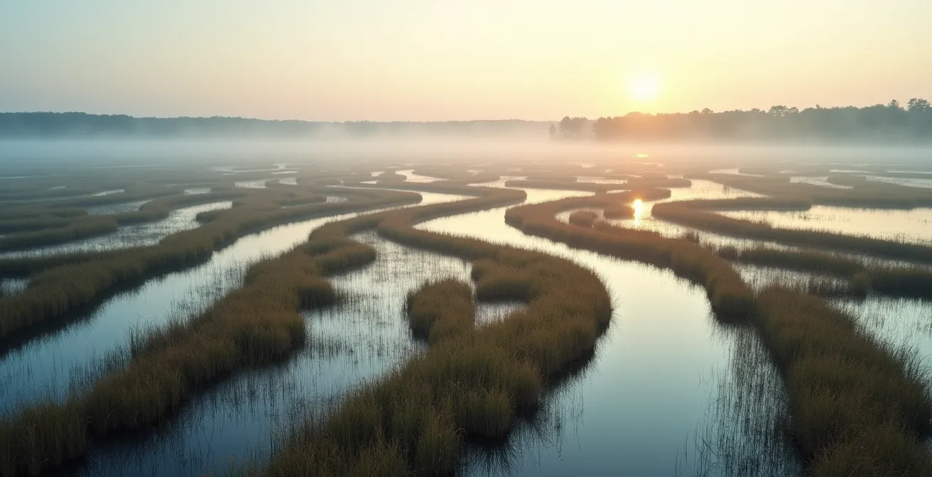
The primary reason wetlands are so effective at mitigating floods lies in a core hydrological principle: hydraulic roughness. A smooth, concrete-lined channel (a pipe or levee) is designed for maximum conveyance—to move water away as quickly as possible. This efficiency, however, simply transfers the flood risk downstream, often with increased velocity and destructive force. A wetland, by contrast, is designed for maximum impedance. The dense network of stems, roots, and leaves from reeds, grasses, and shrubs creates immense friction, drastically slowing the water’s velocity.
Think of it as the difference between water flowing over a smooth tiled floor versus a thick shag carpet. The carpet’s fibers create drag, holding the water back and giving it time to be absorbed. This slowing effect, known as peak flow attenuation, is critical. It reduces the height of the flood crest and desynchronizes the timing of peak flows from various tributaries, preventing them from combining into a larger, more destructive flood wave downstream. Unlike a levee, which only contains water until it is overtopped or breached, a wetland actively dissipates the energy of the flood.
Case Study: The Charles River Natural Valley Storage Area
The flood control effectiveness of wetlands is not merely theoretical. On the Charles River in Massachusetts, the U.S. Army Corps of Engineers conducted an analysis and determined that preserving 8,100 acres of floodplain wetlands was a more reliable and cost-effective flood control strategy for protecting Boston than building extensive new dams and levees. They subsequently purchased the land and designated it for flood storage, a landmark decision that validated natural infrastructure as a primary engineering solution.
This principle of working with natural friction rather than fighting water with rigid walls is the foundation of wetland-based flood defense. It’s a shift from a strategy of containment, which is prone to catastrophic failure, to a strategy of energy dissipation and absorption, which is inherently more resilient.
How to Spot a Dried-Up Peatland That Needs Rewetting?
Peatlands are a specific and highly valuable type of wetland for flood control. Formed over millennia, their soil is composed of partially decomposed organic matter, giving them a phenomenal capacity to store water. However, many have been drained for agriculture or development, turning them from assets into liabilities. A dried-out peatland is not only a source of carbon emissions but also loses its flood storage function. Identifying these degraded areas for rewetting is a crucial first step in a regional flood mitigation strategy.
The visual cues of a degraded peatland are unmistakable to a trained eye. The most obvious sign is subsidence and desiccation cracks. As the organic soil dries, it shrinks and compacts, causing the ground level to drop and deep, polygonal cracks to form across the surface. This is often accompanied by a change in vegetation; the diverse, water-loving sedges and mosses are replaced by monocultures of rushes or invasive terrestrial plants that can tolerate drier conditions. The soil itself changes color from a dark, rich brown to a lighter, oxidized tone and becomes crumbly and dusty to the touch.

These physical signs indicate a loss of hydrological function. The cracked soil can initially increase runoff speed, and the compacted peat has a greatly reduced ability to absorb and hold water. Finding these areas is the first step toward restoration projects, which often involve blocking drainage ditches to raise the water table and re-saturate the peat.
Action Plan: Auditing a Potential Peatland Restoration Site
- Identify Points of Contact: Map all artificial drainage channels, ditches, and agricultural tiles that are currently drawing water away from the site. These are the primary intervention points.
- Collect Baseline Data: Inventory the existing vegetation, noting the dominance of dry-tolerant species over typical wetland plants. Take soil samples to assess moisture content and degree of oxidation.
- Assess for Coherence: Compare the site’s current state to historical aerial photos or soil maps to confirm it was once a wetland. Ensure its topography logically fits within the local watershed for effective rewetting.
- Evaluate Mémorability and Function: Look for the tell-tale signs of degradation—deep cracks, soil subsidence, and lack of sphagnum moss. This visual evidence confirms a loss of water storage function.
- Develop an Integration Plan: Prioritize blocking the most effective drainage points first. Create a phased plan for rewetting to control the process and monitor its impact on the water table and downstream areas.
Restoring Old Wetlands or Digging New Ones: Which Works Faster?
When a municipality decides to invest in wetland infrastructure, a critical question arises: is it better to restore a drained, historic wetland or to construct a new one from scratch? From a hydrological and economic standpoint, the evidence is overwhelmingly in favor of restoration. While constructed wetlands can provide some flood control benefits, they rarely match the efficiency and complexity of a natural system that has evolved over centuries.
The primary reason is soil structure and hydrology. A natural wetland possesses a complex, mature soil profile and an established connection to the local groundwater and surface water flow paths. Re-establishing these conditions is a slow, difficult, and often impossible task in a constructed system. As a result, studies show that preserving and restoring natural wetlands is more economically efficient than draining them, installing grey infrastructure, and then attempting to replicate their function with a man-made wetland.
The process of draining a natural wetland fundamentally alters soil composition and water flow patterns. Restoring it, often by simply blocking artificial drainage, allows the natural hydrology to reassert itself relatively quickly. Constructing a new wetland requires extensive earthmoving, careful placement to integrate with existing stream flows, and a long maturation period for soil and vegetation to develop. The rich biodiversity and habitat value of a natural wetland are also lost during construction and can take decades to recover, if ever.
When a natural wetland is drained, the soil and water flow patterns are usually changed. Constructed wetlands have to be carefully placed to drain into the natural stream flow as well as to capture incoming runoff from urban areas. The valuable habitat provided by natural wetlands is often lost, even during construction of new wetlands.
– Tinkers Creek Watershed Partners, Wetlands as a Tool for Flood Control and Prevention
Therefore, for achieving effective flood control faster and more cost-effectively, the strategic priority should always be to identify and restore degraded natural wetlands first. Construction should be considered a secondary option where no viable restoration opportunities exist.
The Planting Mistake That Turns Wetlands Into Monocultures
Once a restoration project is underway, the focus shifts to implementation. A common and critical mistake made with good intentions is the selection of plant species. To maximize hydraulic roughness, planners might be tempted to plant vast areas with a single, fast-growing, and robust species like the common cattail (Typha latifolia). While this approach can quickly establish vegetative cover, it creates a fragile monoculture that undermines the long-term resilience of the wetland system.
A biodiverse wetland with a mix of native sedges, rushes, grasses, and flowering plants is far more resilient than a monoculture. Different species have different root depths, growth seasons, and resistance to various stressors. If a disease or pest specific to cattails sweeps through a monoculture wetland, the entire system’s vegetative structure could collapse in a single season, eliminating its flood control function. In a diverse system, the loss of one species is compensated for by others, ensuring the overall structural integrity and hydraulic roughness of the wetland remains intact.
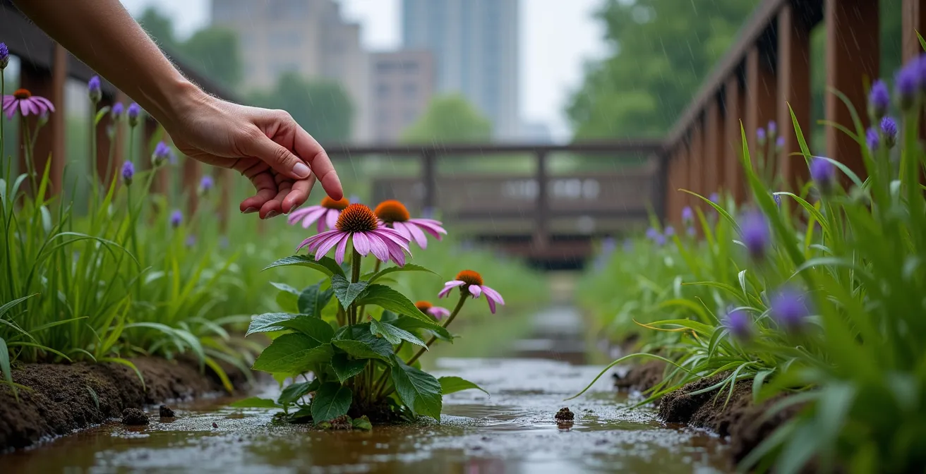
Furthermore, a variety of plant species creates a more complex physical structure both above and below the water. This diversity in stem size, density, and flexibility leads to a more intricate and effective network for slowing water and trapping sediment. A monoculture, by contrast, presents a uniform and less complex barrier. The goal of wetland engineering is not just to build a “green wall” but to foster a dynamic, self-regulating ecosystem. The resilience of that ecosystem is directly tied to its biodiversity. Therefore, restoration plans must include a carefully selected palette of multiple native species to create a robust and sustainable flood control asset.
Choosing expediency over biodiversity is a short-sighted engineering decision. It prioritizes initial appearance over long-term functional resilience, a mistake that can have costly consequences when the system is inevitably tested by environmental stressors.
When to Block the Drains: Timing Restoration to Avoid Downstream Flooding?
While restoring wetlands by blocking drainage is highly effective, the process itself must be carefully managed. A more advanced approach to wetland management involves not just permanent restoration but active, real-time control of water levels. This strategy treats the wetland as a managed reservoir, optimizing its storage capacity immediately before a predicted storm event. This proactive approach represents the pinnacle of integrating natural infrastructure into a modern, data-driven flood management system.
The concept, explored in regions like the Brahmaputra basin, involves creating controlled outlets for wetlands, lakes, and reservoirs. In normal conditions, water levels are kept at a level that supports the ecosystem. However, when an extreme rainfall event is forecast, these outlets are opened to release a controlled amount of water downstream *before* the storm arrives. This pre-emptive drawdown frees up a significant volume of dynamic storage capacity. When the storm hits, the wetland has a much greater ability to absorb and detain the incoming floodwaters, drastically reducing the peak discharge downstream.
The potential for this strategy is immense. For example, one study proposed that by increasing wetland area and depth, it would be possible to achieve massive reductions in flood discharge. A simulation showed that if the wetland area is increased by 30% and the average depth is raised to 3 meters, discharge can be reduced by up to 3,500 m³/s during a peak event. This is a level of performance that would require colossal and costly grey infrastructure to match.
This strategy requires a sophisticated network of monitoring stations, reliable weather forecasting, and automated gate controls. However, it transforms the wetland from a passive flood buffer into an active, high-performance flood control asset. It addresses a key concern of downstream communities: the fear that wetland restoration could inadvertently cause flooding by releasing stored water at the wrong time. By timing the release proactively, this risk is mitigated, and the system’s overall effectiveness is magnified.
Building a Storm Drain or Planting a Rain Garden: Which Costs Less?
On a smaller, urban scale, the same principles apply. Municipalities constantly face the choice between expanding traditional stormwater systems (storm drains, concrete channels) and implementing green infrastructure like rain gardens and bioswales. While the upfront cost of digging a trench and laying a pipe can sometimes seem more straightforward, a comprehensive analysis of total cost and benefits reveals that natural solutions are overwhelmingly more economical.
Rain gardens are essentially small-scale wetlands designed to capture runoff from impervious surfaces like roofs and parking lots. They use the same principles of hydraulic roughness and soil absorption to slow water and filter pollutants. The economic advantages are twofold. First, the direct financial costs of flood damage are significantly reduced. A study from the University of Waterloo estimated that leaving wetlands and natural green spaces intact could reduce the financial costs of floods by up to 38%. This is a direct saving on insurance claims, infrastructure repair, and business disruption.
Second, green infrastructure provides numerous co-benefits that grey infrastructure does not. These “ecosystem services” have tangible economic value. They improve air and water quality, increase property values, provide recreational space, and create habitat. A report from The Nature Conservancy quantified the value of just one of these services, finding that on average, one square kilometer of wetlands provides approximately $36 million in storm protection value annually. Storm drains provide none of these additional benefits; they are a single-purpose asset with high maintenance costs.
When viewed through the lens of Total Cost of Ownership (TCO) and a full cost-benefit analysis, the choice is clear. While a storm drain is a depreciating asset requiring constant maintenance, a rain garden or wetland is an appreciating asset that delivers an expanding portfolio of valuable services to the community over its lifetime.
Why Are Beaches Disappearing Downstream of Hydro Dams?
The effectiveness of flood control solutions cannot be viewed in isolation. All interventions in a watershed have cascading effects, and one of the most significant impacts of large-scale grey infrastructure like hydroelectric dams is coastal erosion. Many coastal communities are witnessing their beaches disappear, a phenomenon directly linked to upstream sediment management. This highlights another critical, often overlooked, function of natural wetland systems.
Rivers and streams naturally carry a load of sand, silt, and clay from the mountains to the sea. This sediment transport is the lifeblood of coastal ecosystems, continually replenishing beaches and deltas. Hydroelectric dams act as giant sediment traps. The reservoir behind the dam slows the water, causing its suspended sediment load to settle out. The clear water released from the dam, known as “hungry water,” has renewed erosive power and scours the riverbed downstream without depositing new material.
The result is a net loss of sediment reaching the coast. Beaches, starved of their natural supply of sand, begin to erode under the constant pressure of waves and sea-level rise. This not only destroys valuable recreational areas and property but also removes the coast’s first line of defense against storm surges. Coastal wetlands, particularly in delta regions, play a crucial role in this process. They help trap and distribute sediment in a beneficial way, building up land and buffering the coast from wave energy. By disrupting the entire sediment-delivery system, upstream dams create a downstream vulnerability that can be just as costly as a flood.
This demonstrates the systemic thinking required in hydrological engineering. A solution in one part of the watershed (a dam for power and flood control) can create a severe problem in another (coastal erosion). An integrated approach that includes wetland restoration can help mitigate these effects by creating areas for natural sediment deposition and buffering the impacts of large-scale grey infrastructure.
Key Takeaways
- Hydraulic Roughness: The physical friction from wetland vegetation is the key mechanism for slowing water and dissipating flood energy, making it fundamentally different from concrete channels.
- Restoration Over Construction: Restoring drained, natural wetlands is faster, more cost-effective, and hydrologically superior to building new, artificial ones due to mature soil and established hydrology.
- Biodiversity Equals Resilience: Planting diverse native species is critical for the long-term stability and function of a wetland, whereas monocultures are fragile and prone to system collapse.
How to Calculate the Dollar Value of a City Tree?
While the title asks about a city tree, the core question for planners is broader: how do we assign a credible dollar value to a natural asset like a wetland? To justify large-scale investment in green infrastructure, we must move from qualitative appreciation to quantitative valuation. This calculation is essential for comparing wetland restoration projects against grey infrastructure alternatives in budget proposals and long-term strategic plans.
The valuation can be broken down into several key components. The most direct value is its avoided cost. This is calculated by estimating the cost of flood damage that the wetland prevents. According to the EPA, a single acre of wetland can store up to 1.5 million gallons of floodwater. A planner can translate this storage capacity into the reduced size and cost of downstream culverts, levees, or the avoided costs of property damage from a modelled flood event.
Next is the value of its ecosystem services. These are the co-benefits that have real market or non-market value, such as water filtration (reducing municipal water treatment costs), carbon sequestration (which can be sold as carbon credits), and increased property values for adjacent real estate. Each of these can be assigned a dollar value based on market rates or economic studies.
The Definitive Return on Investment
Perhaps the most compelling metric for a municipal planner is the direct return on investment (ROI). A comprehensive analysis by The Nature Conservancy synthesized data from numerous projects and found that, on average, every $1 spent on wetland and reef restoration projects results in $7 of direct, measurable flood reduction benefits. This 7:1 ROI presents an incredibly strong business case that is difficult for any single-purpose grey infrastructure project to match.
By combining avoided costs, the monetized value of ecosystem services, and the proven ROI, a robust financial case can be built. This transforms the conversation from “spending money on the environment” to “investing in high-performance, multi-benefit infrastructure.”
Ultimately, integrating wetlands into our flood control strategies is not an act of nostalgia but a forward-looking engineering decision. It is an investment in a resilient, cost-effective, and high-performance infrastructure that protects communities while delivering a wealth of additional benefits. To effectively mitigate future flood risks, the next step is to begin identifying restoration opportunities and incorporating these quantitative valuations into your regional planning.